
If you ever look for the history of Million Dollar Mile you will find out that a million dollars was an astronomical amount of money to spend on such a short strip of road back in 1948. What you will learn is that the construction workers and engineers had to make the costly ramp to the sheer basalt cliff and cut through it. ‘They had to’ is usually the reason given. But why?
First let’s take a quick look at the Million Dollar Mile of State Route 155.
Leaving Coulee City, the Million Dollar Mile starts about nine miles out with about a 400 foot ramp comprised of fill leading up to almost the top of a 600 foot basalt cliff where the highway then enters the first of two tight, narrow basalt cuts before working it’s way back down the Coulee floor once more on a man made ramp. If you follow the highway further it winds down by Banks Lake, rolling over corners of filled roadways and snaking around the lake. The question comes to mind; why not simply go around Million Dollar Mile and save money, why make the highway go up a sheer cliff, through that cliff wall, and then precariously back down the otherside on more fill?
The story goes back to the days before cars, when people would travel between Coulee City and Steamboat Rock on horseback, or with a buggy or wagon. About nine miles out from Coulee City were alkali flats known as the Alkali Sinks to the locals. Alkali flats are not uncommon in the Coulee, in fact, they are everywhere, but these ones where exceptionally bad. They surrounded a huge lake referred to as the Alkali Flats Lake. Alkali Flats Lake covered most of the Coulee Floor in the area around where the Million Dollar Mile would go. The flats occupied a narrow section of the coulee with a slight bend, and when the spring run off came it always brought troubles trying to navigate around it. The lake would swell, and the alkali saturated mud around it would become like gluey quicksand, swallowing down anything it that dared venture into it. Many old boots found there fate at the bottom after being sucked off unsuspecting feet. If a cow should get in to far, perhaps going for a drink of water, they would become afixed like a insect on fly paper and have to be lassoed and wrangled out with much effort. The mud was rumored to be a thousand feet deep, with some of the more liberal minded were willing to call it bottomless. These were the Alkali Sinks, the La Brea Tar Pits of the Coulee. But of course, the Sinks weren’t always threatening, the hot sun would bake the surface into a hard cracked clay during the hot summer months, and the lakes level would drop, revealing more of the alkali laced mud, then winter would come and it would all freeze, most times solid. People just learned to live with it, it was everyday life.
The 1920’s rolled around bringing a few automobiles to the area and the roads slightly improved over the decades, with the solution always being to skirt around the Sinks and as time passed they became less threatening to the people who had adapted and moved onto other issues. Rarely the Sinks made topic and were almost forgotten except by a few old timers.
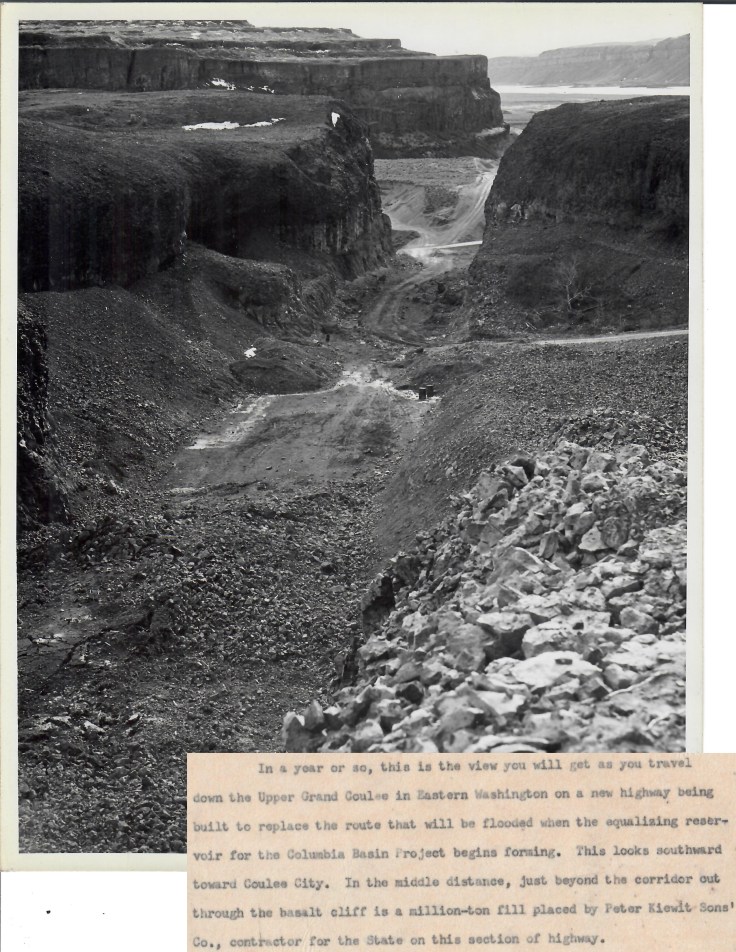
By the mid 1930’s Grand Coulee Dam was under construction at the other end of the coulee, about 10 miles past Steamboat Rock at Seaton’s Ferry. This was bringing people from all over into the coulee, one of them was David H Ryan. He had won the contract to build the US Construction Railroad from Odair down through the coulee to where the dam was being built on the Columbia. As he started, with a mule team according to records, people gathered around to watch curiously. The dam at the other end of the coulee was the big story and everyone was curious to find out more, and what was happening. As more machinery arrived so did more rubberneckers, people craning their neck and traveling out to the construction sight to see what all the fuss was about. When the locals caught wind of Ryan’s plan to go through the Alkali flats just outside of town they warned him about the gluey quicksand like mud. But David Ryan, pushed for time moved ahead anyway, placing his tracks through what appeared to be a dry alkali bed. The crew then pushed ahead down the coulee, laying tracks at record breaking speeds. By the time snows began to fall in the coulee the tracks had moved beyond Steamboat Rock and were all the way down by the dam site. When the spring rains came and melted the snow there was a huge run off. Water cascaded down the coulee walls from flooded streams and seasonal lakes filling the long dormant and forgotten Alkali Sinks, bringing them back to life. David Ryan in a bid to save the tracks sent in a couple steam shovels but they were no match for the mud as one of them toppled over into the muck. It was a folly and there was nothing Ryan could do but rebuild. He did so on the side with the highway which had also been flooded by the spring deluge.
Eventually the railroad was finished, as well as the highway which was dubbed “The Speedball Highway.” Now people could easily drive down the coulee past Alkali Flats Lake, Horse Lake, Tule Lake, on up past Steamboat Rock and Devil’s Lake to the marvel in the desert: Grand Coulee Dam. The dam was put online to produce electricity just as the second World War struck, delaying the building of the irrigation part of the project until the end of the war. Finally, in 1948 the building of the new highway began, the road that became SR 155, also known as the Coulee Boulevard, and with it, the Million Dollar Mile.
I would love to say it is because of the Alkali Sinks that the engineers decided to go up a shear basalt rock face than around it. Alkali Flats Lake wasn’t really a factor because it was going to be flooded anyway, but the stability of the shore around it was, there was no real solid bedrock to be found on the floor around the area once known as the Sinks. Alkali Flats Lake probably wasn’t 1000 feet deep as once believed, but the muddy shore once known as the Sinks made it unstable for fill so the new highway had to go over the cliff rather than around. Plus, at the top of the cliff right where the road ended up going was a huge hollow natural pothole that could easily be blasted out. They just had to get the highway up to it, cut a pathway through the basalt rock with dynamite and then create a ramp of fill down the other side. Which they did, allowing a new generation of horseless carriages free access up and around the once dreaded Alkali Sinks, up past Alkali Flats Lake, through a huge lava bubble and safely on their way.


just north of coulee city were some large apple orchards. My mother worked there sometime during the late thirties as a cook. I was probably 4 or 5 so didn’t have to work 🙂 but did get to stir the jello once in a while.
Also remember slightly when we would pass by a settlemen….Rimrock, which was just a few buildings alongside the highway